It’s no secret I love walking solo in the woods and countryside around my hometown.
When I found this quote “I come to my solitary woodland walk as the homesick go home.” by Henry David Thoreau I thought it suited me completely.
Then I found that there was a word that also described me completely:-nemophilist a noun that means “a person who is in love with the forests and woods, and the beauty and solitude they offer; this person is a haunter of the woods.”
A poet Mary Oliver wrote a poem: How I go to the woods that starts:-
“Ordinarily I go to the woods alone, with not a single friend, for they are all smilers and talkers and therefore unsuitable.”
And ends:-
“If you have ever gone to the woods with me, I must love you very much.”
This is very true of me too. If I walk with you, especially when walking in the countryside and woods, then I love you.
Heaven to me as I walk is hearing the sound of the wind, the birds, and animals. Human voices can become a distraction.
All photos are described in the text.
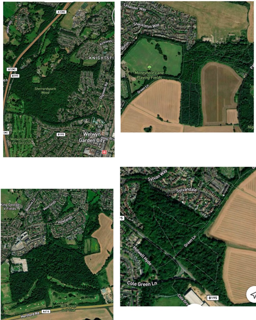
I’m so lucky that the town I live in (Welwyn Garden City) has protected woods on the edge of town almost all with public footpaths. In the collage above are the largest woods in town.
Top left:- Sherrardspark Wood is a Nature Reserve on the West edge of town and just off of the town centre. It’s immediately behind our entertainment complex Campus West (cinema, theatre, soft play, roller skate rink) and main library on the North Edge of the largest shopping area. It is a shortish walk from the Bus and Train Stations. You may notice that long strip of thin trees at the bottom of the woods it runs behind the Campus West and the college running along an old railway. It used to contain the brickworks that made bricks for the first houses built in the town 104 years ago (before then the town was woods, farms, and hamlets).
Top right:- Moneyhole Playing Fields and woods. This area is on the North east of town. The playing fields area has a children’s play area, a basketball court, some football pitches and the large are with a few trees on it that are good for dog walking, etc. On the edge closest to the houses (North West) a path runs through trees which form a break between the houses and the park. Some people have chosen to have gates from their gardens into this area. The area marked Green Lane (South West) is another thin wooded break that connects another wood, and separates the houses from the farm fields. The field at North West above the woods is the former airfield which will become a new housing development (it was a decoy during the 2nd World War to protect air manufacturing in Hatfield). The woodland wraps around a farm field on the right hand of the photo, West and North of the farm field the woods have public footpaths, but east of the field they cross a country road and become private land.
Bottom Right is the area of wood that connects to Green Lane, which is still separating houses from farm fields, there’s only a couple of paths either side of the “lane” which crosses the Hertford Road to link to a route I regularly used to use to visit my sister before my sight loss when I was walking my dog. Most of this area is overgrown with brambles, there is an old pillbox from the World War 2 next to path on the edge of the woods near the farm fields.
Bottom left is Commonswood on the South of town which used to be a larger area accessible by the public in my childhood (all the woodland down to the A414). Where the Golf Club is just above the A road was an old quarry area that had naturally become a field. Now the actual area open to the public is there area between farmers fields and houses on the right then the strip on the north east edge of the main woods. The area of houses just above and to left used to be part of the land belonging to the Queen Elizabeth Hospital which has been replaced with the New Queen Elizabeth Hospital (just outpatient clinics, blood tests, “minor” treatments, and limited urgent care) and a housing estate.
Below is a collage entitled “On the edge of town” of some of my walks.
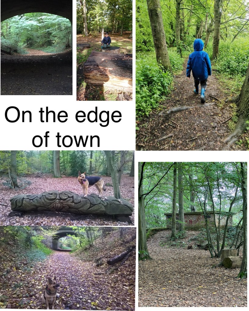
Top right:- my grandson walking through the trees in Commonswood, the more open area on the right has a small stream running alongside.
Bottom right:- on the edge of Moneyhole Woods closest to Panshanger airfield is a low brick built building enclosed by a low wall from World War 2 (my guess is somewhere where personnel went during air raids, a friend suggested back up communications).
On the left the 4 photos are from Sherrardspark Wood with the title.
Above the title the 2 photos are portait in orientation. On the right is my grandson sitting on a cut tree stump by some cut logs with a post behind him indicating one of the bridle paths with a horseshoe.
Above the title on the left looking under the bridge when I was standing behind the college. I’m looking towards the “rustic” steps on the left that take you up to street level round the corner from the library. Also looking along the old railway track called the Ayot Green Way which has paths that take you over the A1(M) to link up with paths to the Ayots and other villages which I hope to explore further when it gets drier. It is the direction to get into the woods.
Below the title the 2 photos are in landscape orientation. Bottom is my dog Tippy sitting on the path with the same bridge as above behind her. We had walked along the path a bit so the steps are hidden behind the saplings on the right as I look towards the path under the bridge behind the college.
Top is Tippy standing in a clearing on a carved log depicting the Greene Man (eyes, nose, and mouth surrounded by leaves).
For my blind readers Tippy looks like a black and tan border collie sized German shepherd. By the bridge she is sitting square on to me with her head looking to the right (she was watching a squirrel). On the Greene Man her body is facing left and head facing right as she watches a bird on the ground.

Leave a comment